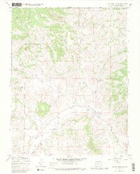
1967 Map of Lake Mountain NE
USGS Topo · Published 1980About this map
The Rio Grande National Forest dominates this mountain landscape, defined by a network of drainage systems feeding into the Saguache Creek valley. Surveyed in the late 1960s, the terrain shows a transition from high ridges and peaks like Houghland Hill to deep cuts like Polson Creek and Tree Lane Gulch. Human presence is sparse but concentrated along drainage routes, where a Jeep Trail and various pipelines navigate the elevation changes. Evidence of early land use and local industry is preserved through the presence of a Mine and a Gravel Pit, while the remote Jacks Creek Cem serves as a lone genealogical marker for the families who once worked these drainages. Scientific monitoring is noted at a Gaging Sta along the creek, underscoring the importance of water management in this arid mountain environment.
Find a feature on this map
28 named features on this map. Tap any name to fly to it.
Don’t see what you’re looking for? This feature index may not catch every label — zoom into the map to look around manually.
Map Details
Editions of this 1967 Lake Mountain NE Map
3 editions found
Other maps of this area

1956 · Montrose
USGS Topo · 1:250,000

1959 · Montrose
USGS Topo · 1:250,000

1959 · Bonanza
USGS Topo · 1:62,500

1960 · Montrose
USGS Topo · 1:250,000

1967 · Sargents Mesa
USGS Topo · 1:24,000
1967 · Laughlin Gulch
USGS Topo · 1:24,000

1967 · Trickle Mountain
USGS Topo · 1:24,000

1967 · Lake Mountain NE
USGS Topo · 1:24,000
1967 · Lake Mountain NE
USGS Topo · 1:24,000

1967 · Chester
USGS Topo · 1:24,000