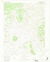
1967 Map of Lake Mountain NE
USGS Topo · Published 1980About this map
Rio Grande National Forest defines much of this high-elevation landscape in the late 1960s, where a network of gulches and creeks drains toward the south. The terrain is marked by significant natural landmarks such as Castle Rock and Houghland Hill, while smaller human interventions indicate localized activity. A Mine and Gravel Pit appear alongside drainage features like Ford Gulch and Mill Gulch, suggesting early industrial interests in the local geology.
Find a feature on this map
22 named features on this map. Tap any name to fly to it.
Don’t see what you’re looking for? This feature index may not catch every label — zoom into the map to look around manually.
Map Details
Editions of this 1967 Lake Mountain NE Map
3 editions found
Other maps of this area

1956 · Montrose
USGS Topo · 1:250,000

1959 · Montrose
USGS Topo · 1:250,000

1959 · Bonanza
USGS Topo · 1:62,500

1960 · Montrose
USGS Topo · 1:250,000

1967 · Sargents Mesa
USGS Topo · 1:24,000
1967 · Laughlin Gulch
USGS Topo · 1:24,000

1967 · Trickle Mountain
USGS Topo · 1:24,000

1967 · Lake Mountain NE
USGS Topo · 1:24,000
1967 · Lake Mountain NE
USGS Topo · 1:24,000

1967 · Chester
USGS Topo · 1:24,000