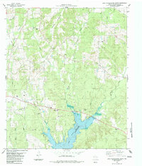
1983 Map of Lake Nacogdoches North
USGS Topo · Published 1983About this map
Lake Nacogdoches dominates the southern reaches of this survey, its waters reaching into the creek valleys of central Nacogdoches County. The landscape is characterized by a network of bayous and creeks, including Loco Bayou and Yellow Bank Creek, which drain the area surrounding Flower Mountain. Small rural communities like Nat, Winter Hill, and Red Flat serve as local anchors, connected by light-duty roads and an emerging infrastructure of gas development, evidenced by numerous Gas Well sites and a prominent Pipeline.
Find a feature on this map
25 named features on this map. Tap any name to fly to it.
Don’t see what you’re looking for? This feature index may not catch every label — zoom into the map to look around manually.
Map Details
Editions of this 1983 Lake Nacogdoches North Map
This is the sole edition of this map. No revisions or reprints were ever made.
Other maps of this area

1943 · Cushing
USGS Topo · 1:62,500

1945 · Cushing
USGS Topo · 1:62,500

1952 · Douglass
USGS Topo · 1:62,500

1952 · Nacogdoches
USGS Topo · 1:62,500

1953 · Palestine
USGS Topo · 1:250,000

1957 · Palestine
USGS Topo · 1:250,000

1960 · Mount Enterprise
USGS Topo · 1:62,500

1973 · Cushing
USGS Topo · 1:24,000
1973 · Reklaw
USGS Topo · 1:24,000
1983 · Durst Lakes
USGS Topo · 1:24,000