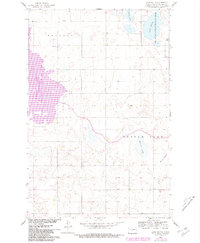
1961 Map of Lake Nettie
USGS Topo · Published 1981About this map
Lake Nettie National Wildlife Refuge and the eastern margins of the Audubon National Wildlife Refuge anchor this McLean County landscape, where the prairie meets a complex system of glacial wetlands and water management. A significant Canal system and a Lock represent the mid-century engineering efforts of the Missouri River Basin development, which sought to manage the region's hydrology. Between the townships of Malcolm and Turtle Lake, the map documents a rural community centered around its local institutions, including School No 1, School No 5, and a Community Hall. Local heritage is marked by Bethel Ch, its adjacent Cem, and the Darling Cem. The natural terrain is defined by numerous depressions and water bodies like Crooked Lake, Nygaard Slough, and Hanson Slough, illustrating the characteristic prairie pothole geology of central North Dakota.
Find a feature on this map
17 named features on this map. Tap any name to fly to it.
Don’t see what you’re looking for? This feature index may not catch every label — zoom into the map to look around manually.
Map Details
Editions of this 1961 Lake Nettie Map
2 editions found
Other maps of this area

1929 · Coleharbor
USGS Topo · 1:62,500

1947 · Turtle Lake
USGS Topo · 1:62,500

1949 · Turtle Creek
USGS Topo · 1:62,500

1949 · Washburn
USGS Topo · 1:62,500

1954 · McClusky
USGS Topo · 1:250,000

1958 · McClusky
USGS Topo · 1:250,000

1961 · Turtle Lake
USGS Topo · 1:24,000

1961 · Lake Nettie
USGS Topo · 1:24,000

1961 · Washburn NE
USGS Topo · 1:24,000

1961 · Turtle Creek NW
USGS Topo · 1:24,000