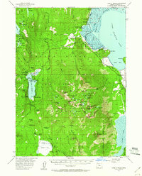
1955 Map of Lake O' Woods
USGS Topo · Published 1960About this map
Harriman Lodge and Pelican Guard Station anchor the northwestern shores of Upper Klamath Lake, marking a period of established lakeside recreation and federal land management. This 1955 field survey reveals the complex hydrologic network of the southern Cascades, where the Rye Spur Canal and Cascade Canal divert waters through the high-elevation terrain. The landscape is defined by the volcanic topography of the Mountain Lakes Wild Area, featuring prominent summits like Whiteface Peak and Aspen Butte surrounded by a dense cluster of alpine basins such as Clover Lake and Lake Waban. Along the shores of Lake O' Woods, several youth and recreational sites including Camp Esther Applegate and Camp McLoughlin illustrate the mid-century importance of this area as a regional destination. The Skyline Trail traverses the western ridges, providing a vital link through the Rogue River National Forest for backcountry travelers before modern expansion.
Find a feature on this map
90 named features on this map. Tap any name to fly to it.
Don’t see what you’re looking for? This feature index may not catch every label — zoom into the map to look around manually.
Map Details
Editions of this 1955 Lake O' Woods Map
3 editions found
Other maps of this area

1889 · Klamath
USGS Topo · 1:250,000

1891 · Ashland
USGS Topo · 1:250,000

1893 · Ashland
USGS Topo · 1:250,000

1894 · Klamath
USGS Topo · 1:250,000

1897 · Ashland
USGS Topo · 1:250,000

1955 · Lake O' Woods
USGS Topo · 1:62,500

1955 · Surveyor Mtn
USGS Topo · 1:62,500

1955 · Rustler Peak
USGS Topo · 1:62,500

1955 · Hyatt Reservoir
USGS Topo · 1:62,500

1955 · Mt. Mc Loughlin
USGS Topo · 1:62,500