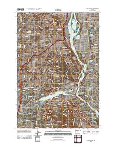
2011 Map of Lake Oswego
USGS Topo · Published 2011About this map
Portland and its southern suburbs are defined by the winding course of the Willamette River in this 2011 topographic survey. The landscape transitions from the urban density of Brooklyn and Sellwood to the more residential developments of Lake Oswego and West Linn. Significant institutional and memorial grounds occupy large tracts of land, including Oregon Health Sciences University School of Dentistry on Marquam Hill and a concentration of historic burial sites such as Riverview Cemetery and Beth Israel Cemetery.
Find a feature on this map
206 named features on this map. Tap any name to fly to it.
Don’t see what you’re looking for? This feature index may not catch every label — zoom into the map to look around manually.
Map Details
Editions of this 2011 Lake Oswego Map
This is the sole edition of this map. No revisions or reprints were ever made.
Other maps of this area

1897 · Portland
USGS Topo · 1:62,500

1905 · Portland
USGS Topo · 1:62,500

1914 · Oregon City
USGS Topo · 1:62,500

1915 · Hillsboro
USGS Topo · 1:62,500

1916 · Tualatin
USGS Topo · 1:62,500

1918 · Hillsboro
USGS Topo · 1:62,500

1939 · Oregon City
USGS Topo · 1:62,500

1939 · Tualatin
USGS Topo · 1:62,500

1940 · Tualatin
USGS Topo · 1:62,500

1940 · Hillsboro
USGS Topo · 1:62,500