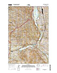
2014 Map of Lake Oswego
USGS Topo · Published 2014About this map
The Willamette River defines the eastern geography of this 2014 survey, winding past Ross Island and Hardtack Island toward the southern reaches of Lake Oswego. The landscape is a dense network of suburban development and historical institutions, featuring several significant cemeteries such as Beth Israel Cem and the Oswego Pioneer Cem. Education is a central theme, with the Oregon Health and Science Univ dominating Marquam Hill in the north, while the Portland Community Coll Sylvania Campus sits near the summit of Mt Sylvania. The map illustrates a complex transit infrastructure, from the recreational Springwater Corridor to the industrial and commuter routes serving Tigard, Beaverton, and the many hills and heights of southwest Portland. Numerous park-and-ride locations at sites like the Christ Church Parish Park and Ride highlight the modern commuter character of these historic residential enclaves.
Find a feature on this map
116 named features on this map. Tap any name to fly to it.
Don’t see what you’re looking for? This feature index may not catch every label — zoom into the map to look around manually.
Map Details
Editions of this 2014 Lake Oswego Map
This is the sole edition of this map. No revisions or reprints were ever made.
Other maps of this area

1897 · Portland
USGS Topo · 1:62,500

1905 · Portland
USGS Topo · 1:62,500

1914 · Oregon City
USGS Topo · 1:62,500

1915 · Hillsboro
USGS Topo · 1:62,500

1916 · Tualatin
USGS Topo · 1:62,500

1918 · Hillsboro
USGS Topo · 1:62,500

1939 · Oregon City
USGS Topo · 1:62,500

1939 · Tualatin
USGS Topo · 1:62,500

1940 · Tualatin
USGS Topo · 1:62,500

1940 · Hillsboro
USGS Topo · 1:62,500