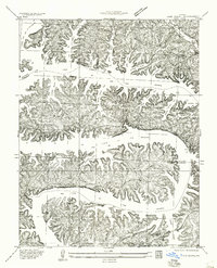
1934 Map of Lake Ozark
USGS Topo · Published 1957About this map
Bagnell Dam anchors this mid-1930s survey of the newly formed reservoir landscape where Morgan, Camden, and Miller counties converge. The intricate shoreline of the Lake of the Ozarks is defined by a labyrinth of drowned valleys including Gravois Arm, Downing Branch Cove, and Jennings Branch Cove. This era captures the early transition from rural river valleys to a managed water resource, seen in the persistence of local institutions like Roberts School and Harpers Chapel alongside burgeoning recreational sites like Lakeview Beach and Cookers Camp. The topography illustrates the complex geography of Horseshoe Bend and Shawnee Bend, where established routes such as Shawnee Bend Road navigated the ridge-tops above the rising waters. Significant landmarks like the School of the Osage and Miller Cem provide critical touchpoints for genealogists and local historians tracing families impacted by the reservoir's creation.
Find a feature on this map
38 named features on this map. Tap any name to fly to it.
Don’t see what you’re looking for? This feature index may not catch every label — zoom into the map to look around manually.
Map Details
Editions of this 1934 Lake Ozark Map
3 editions found
Other maps of this area

1888 · Versailles
USGS Topo · 1:125,000

1893 · Versailles
USGS Topo · 1:125,000

1904 · Eldon
USGS Topo · 1:62,500

1904 · Gravois Mills
USGS Topo · 1:62,500

1932 · Versailles No 4
USGS Topo · 1:48,000

1934 · Camdenton
USGS Topo · 1:24,000

1934 · Purvis
USGS Topo · 1:24,000

1934 · Toronto
USGS Topo · 1:24,000

1934 · Lake Ozark
USGS Topo · 1:24,000

1934 · Bagnell
USGS Topo · 1:24,000