
1934 Map of Lake Ozark
USGS Topo · Published 1934About this map
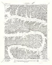
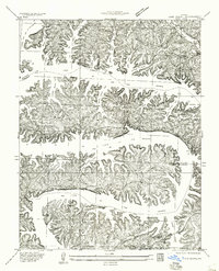
Bagnell Dam anchors this landscape in the early 1930s, showing the early configuration of Lake of the Ozarks shortly after its creation. The intricate, serpentine shoreline is defined by massive peninsulas like Horseshoe Bend and Shawnee Bend, where the rising water flooded numerous branch coves such as Raccoon Hollow Cove and Jennings Branch Cove. Early recreational and residential patterns are visible through the emergence of sites like Lillibridge Camp and Lakeview Beach, contrasting with older rural landmarks like the Roberts School and Harpers Chapel. The map reveals the relocation of life around the new reservoir, featuring the Lake Ozark PO near the dam and the Zebra PO to the south. Local heritage is preserved through small family and community burial grounds, including Riverview Cem and Downing Cem, which remained above the new water line.
Find a feature on this map
61 named features on this map. Tap any name to fly to it.
Don’t see what you’re looking for? This feature index may not catch every label — zoom into the map to look around manually.
Map Details
Editions of this 1934 Lake Ozark Map
3 editions found
Other maps of this area

1888 · Versailles
USGS Topo · 1:125,000

1893 · Versailles
USGS Topo · 1:125,000

1904 · Eldon
USGS Topo · 1:62,500

1904 · Gravois Mills
USGS Topo · 1:62,500

1932 · Versailles No 4
USGS Topo · 1:48,000

1934 · Camdenton
USGS Topo · 1:24,000

1934 · Purvis
USGS Topo · 1:24,000

1934 · Toronto
USGS Topo · 1:24,000

1934 · Bagnell
USGS Topo · 1:24,000

1934 · Green Bay Terrace
USGS Topo · 1:24,000