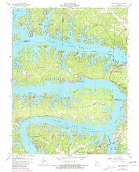
1959 Map of Lake Ozark
USGS Topo · Published 1981About this map
Bagnell Dam anchors this mid-century look at the dramatic shoreline where the Osage River feeds into the Lake of the Ozarks. The map captures a period of significant recreational development following the dam's completion, evidenced by numerous named points and coves such as Duck Head Point, Kays Point, and the residential clusters at Lake Ozark and Osage Beach. Beyond the waterfront, the interior terrain is marked by family-named cemeteries including Miller Cem, Downing Cem, and Riley Lamb Cem, providing essential clues for local genealogical research in Miller, Camden, and Morgan counties. The vast acreage of the Lake of the Ozarks State Park and the Mansfield Forest State Wildlife Management Area highlights the transition of this landscape into a major public conservation and leisure destination.
Find a feature on this map
59 named features on this map. Tap any name to fly to it.
Don’t see what you’re looking for? This feature index may not catch every label — zoom into the map to look around manually.
Map Details
Editions of this 1959 Lake Ozark Map
3 editions found
Other maps of this area

1888 · Versailles
USGS Topo · 1:125,000

1893 · Versailles
USGS Topo · 1:125,000

1904 · Eldon
USGS Topo · 1:62,500

1904 · Gravois Mills
USGS Topo · 1:62,500

1932 · Versailles No 4
USGS Topo · 1:48,000

1934 · Camdenton
USGS Topo · 1:24,000

1934 · Purvis
USGS Topo · 1:24,000

1934 · Toronto
USGS Topo · 1:24,000

1934 · Lake Ozark
USGS Topo · 1:24,000

1934 · Bagnell
USGS Topo · 1:24,000