
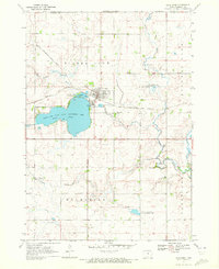
1970 Map of Lake Park SE
USGS Topo · Published 1972About this map
The Little Sioux River meanders through the southeastern corner of this Iowa landscape, marking the transition from the glaciated prairie of Westport and Excelsior townships toward the river valley. The topography is defined by the prairie pothole region's unique hydrology, featuring Stony Lake and the winding course of Stony Creek as it flows southward. This 1970 field check preserves the location of rural landmarks essential for genealogical research, such as the Westport Cem and Excelsior Ch. The map also delineates the jurisdictional boundaries between Dickinson and Clay counties, showing how section lines and section-corner schools once organized this agricultural heartland. Several gravel pits and a prominent pipeline cutting across the northern sections indicate the light industrial footprint within this primarily farming-focused region during the late twentieth century.
Find a feature on this map
14 named features on this map. Tap any name to fly to it.
Don’t see what you’re looking for? This feature index may not catch every label — zoom into the map to look around manually.
Map Details
Editions of this 1970 Lake Park SE Map
This is the sole edition of this map. No revisions or reprints were ever made.
Other maps of this area

1954 · Fairmont
USGS Topo · 1:250,000

1958 · Fairmont
USGS Topo · 1:250,000

1966 · Spencer
USGS Topo · 1:24,000

1970 · Milford
USGS Topo · 1:24,000

1970 · Everly
USGS Topo · 1:24,000

1970 · Okoboji
USGS Topo · 1:24,000

1970 · Hartley
USGS Topo · 1:24,000

1970 · May City
USGS Topo · 1:24,000

1970 · Harris
USGS Topo · 1:24,000
1970 · Lake Park
USGS Topo · 1:24,000