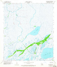
1964 Map of Lake Penchant
USGS Topo · Published 1965About this map
Lake Penchant dominates this mid-1960s survey of the Terrebonne Parish wetlands, where the natural hydrology of the Mississippi Delta meets mid-century industrial expansion. The landscape is a complex web of meandering natural waterways like Copasaw Bayou and Bayou Penchant alongside man-made alterations for resource extraction and navigation. Straight-line incisions such as the Field Gas Canal, Brady Canal, and Billiot Canal illustrate the era's intensifying petroleum exploration, further evidenced by a specific Drill Hole noted in the marsh. To the south, larger open water bodies including Lake De Cade and Jug Lake are connected by Bayou De Cade. The presence of named high ground like Bleux Island and the wooded ridges along Mauvais Bois Bayou highlight the rare habitable or navigable land within this predominantly waterbound environment.
Find a feature on this map
24 named features on this map. Tap any name to fly to it.
Don’t see what you’re looking for? This feature index may not catch every label — zoom into the map to look around manually.
Map Details
Editions of this 1964 Lake Penchant Map
3 editions found
Other maps of this area

1892 · Gibson
USGS Topo · 1:62,500

1894 · Bayou De Large
USGS Topo · 1:62,500

1897 · Gibson
USGS Topo · 1:62,500

1932 · Lake Decade
USGS Topo · 1:62,500

1935 · Theriot
USGS Topo · 1:31,680

1935 · Morgan City
USGS Topo · 1:62,500

1935 · Lake Mechant
USGS Topo · 1:31,680

1935 · Lake Penchant
USGS Topo · 1:31,680

1939 · Gibson
USGS Topo · 1:62,500

1940 · Bayou Du Large
USGS Topo · 1:62,500