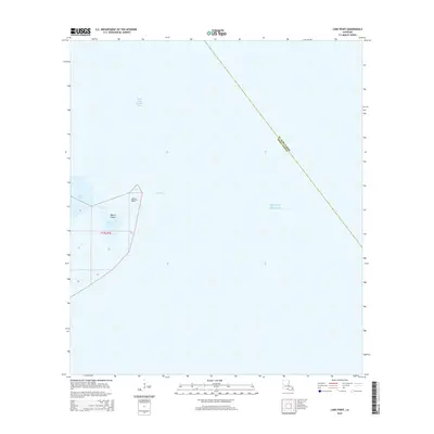
2015 Map of Lake Point
USGS Topo · Published 2015About this map
Marsh Island dominates this coastal survey, where the brackish waters of West Cote Blanche Bay meet the open Gulf of Mexico. The landforms here are shaped by tidal influence and sediment transport, centered on the prominent eastern protrusion of Lake Point. Navigable passages and inlets such as East Pass and Hawkins Bayou cut through the marshy landscape, illustrating the complex hydrography of the Iberia Parish shoreline. This modern topographic study, based on 2013 imagery, documents the precise boundary line between Iberia and St. Mary Parish as it traverses the open water. The map provides a detailed record of section lines within Township 17 South, Range 7 East, essential for researchers tracking coastal land claims and the shifting geography of Lake Sand.
Find a feature on this map
9 named features on this map. Tap any name to fly to it.
Don’t see what you’re looking for? This feature index may not catch every label — zoom into the map to look around manually.
Map Details
Editions of this 2015 Lake Point Map
This is the sole edition of this map. No revisions or reprints were ever made.
Other maps of this area

1932 · Bayou Blanc
USGS Topo · 1:31,680

1937 · Bayou Sale
USGS Topo · 1:62,500

1945 · New Orleans
USGS Topo · 1:250,000
1948 · Bayou Blanc
USGS Topo · 1:24,000

1949 · Cypremort Pt
USGS Topo · 1:31,680
1951 · Lake Point
USGS Topo · 1:24,000
1951 · Mound Point
USGS Topo · 1:24,000

1957 · Bayou Sale
USGS Topo · 1:62,500

1963 · New Orleans
USGS Topo · 1:250,000

1966 · New Orleans
USGS Topo · 1:250,000