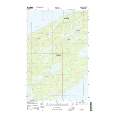
2017 Map of Lake Richie
USGS Topo · Published 2017About this map
Isle Royale National Park defines this wilderness landscape, showcasing a complex network of interior waterways and ancient geological formations. The topography is dominated by the parallel alignments of Minong Ridge and Greenstone Ridge, which create a series of narrow valleys filled with numerous freshwater bodies. Centered on Lake Richie, the area includes significant inland waters like Chickenbone Lake, Lake Whittlesey, and the northern reaches of Siskiwit Lake. The map illustrates the island’s unique northeast-southwest orientation, where the rocky coastline of Lake Superior gives way to deep inlets such as Moskey Basin. This 2017 survey details the remote backcountry terrain, marking the numerous smaller lakes like Lake Eva, Lake Shesheeb, and Lake Wagejo that characterize the interior of Michigan's largest island wilderness.
Find a feature on this map
32 named features on this map. Tap any name to fly to it.
Don’t see what you’re looking for? This feature index may not catch every label — zoom into the map to look around manually.
Map Details
Editions of this 2017 Lake Richie Map
This is the sole edition of this map. No revisions or reprints were ever made.
Other maps of this area

1958 · Hancock
USGS Topo · 1:250,000

1959 · Fort William
USGS Topo · 1:250,000

1960 · Hancock
USGS Topo · 1:250,000

1961 · Hancock
USGS Topo · 1:250,000

1966 · Hancock
USGS Topo · 1:250,000

1968 · Fort William
USGS Topo · 1:250,000

1985 · Todd Harbor
USGS Topo · 1:100,000

1985 · Siskiwit Bay
USGS Topo · 1:100,000
1985 · Lake Richie
USGS Topo · 1:24,000
1985 · Todd Harbor
USGS Topo · 1:24,000