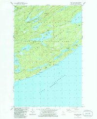
1985 Map of Lake Richie
USGS Topo · Published 1986About this map
Isle Royale National Park is defined by its long ridges and interconnected waterways, shown here during a mid-1980s revision that documents the interior wilderness of Keweenaw County. The landscape is dominated by the parallel structures of Minong Ridge and Greenstone Ridge, which shelter a network of freshwater bodies including the large Lake Richie, Siskiwit Lake, and Lake Whittlesey. Evidence of the island's copper-mining history is preserved in the presence of the Minong Mine and Datolite Mine, illustrating the 19th-century industrial efforts that preceded the area's conservation. The map traces essential backcountry routes such as the Indian Portage Trail and Minong Trail, which connect vital points like Chippewa Harbor and the Moskey Basin shoreline. These trails and portages reflect a traditional transportation network that has remained largely unchanged for decades, serving as the primary infrastructure for navigating the island's interior.
Find a feature on this map
43 named features on this map. Tap any name to fly to it.
Don’t see what you’re looking for? This feature index may not catch every label — zoom into the map to look around manually.
Map Details
Editions of this 1985 Lake Richie Map
2 editions found
Other maps of this area

1958 · Hancock
USGS Topo · 1:250,000

1959 · Fort William
USGS Topo · 1:250,000

1960 · Hancock
USGS Topo · 1:250,000

1961 · Hancock
USGS Topo · 1:250,000

1966 · Hancock
USGS Topo · 1:250,000

1968 · Fort William
USGS Topo · 1:250,000

1985 · Todd Harbor
USGS Topo · 1:100,000

1985 · Siskiwit Bay
USGS Topo · 1:100,000
1985 · Todd Harbor
USGS Topo · 1:24,000
1985 · McCargoe Cove
USGS Topo · 1:24,000