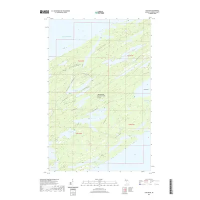
2019 Map of Lake Richie
USGS Topo · Published 2019About this map
Isle Royale National Park reveals a complex network of ancient ridge-and-valley geology oriented southwest to northeast within Lake Superior. The interior of the island is defined by the prominent Greenstone Ridge and Minong Ridge, which create natural basins for a series of linear inland water bodies. This 2019 survey documents the primitive transportation network that facilitates movement across the island's interior, including the Indian Portage Trail, Greenstone Ridge Trail, and the Minong Ridge Trail. These pathways connect significant water features like Lake Richie, Chickenbone Lake, and Intermediate Lake. On the eastern edge, the landscape gives way to Moskey Basin and Wallace Lake, while peaks such as Pine Mtn and Stanley Ridge punctuate the high ground. The map also records several small inland lakes such as Lake Dustin and Lake Shesheeb, highlighting the hydrologic richness of this protected wilderness.
Find a feature on this map
29 named features on this map. Tap any name to fly to it.
Don’t see what you’re looking for? This feature index may not catch every label — zoom into the map to look around manually.
Map Details
Editions of this 2019 Lake Richie Map
This is the sole edition of this map. No revisions or reprints were ever made.
Other maps of this area

1958 · Hancock
USGS Topo · 1:250,000

1959 · Fort William
USGS Topo · 1:250,000

1960 · Hancock
USGS Topo · 1:250,000

1961 · Hancock
USGS Topo · 1:250,000

1966 · Hancock
USGS Topo · 1:250,000

1968 · Fort William
USGS Topo · 1:250,000

1985 · Todd Harbor
USGS Topo · 1:100,000

1985 · Siskiwit Bay
USGS Topo · 1:100,000
1985 · Lake Richie
USGS Topo · 1:24,000
1985 · Todd Harbor
USGS Topo · 1:24,000