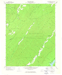
1977 Map of Lake Sherwood
USGS Topo · Published 1978About this map
Anthony Creek carves a deep valley through the heart of the Monongahela National Forest, dividing the high ridges of Middle Mountain and Huntersville Mountain. This 1970s landscape is defined by its conservation and recreational uses, featuring the extensive boundaries of Watoga State Park and Calvin Price State Forest. In the southern reaches, Lake Sherwood serves as a primary focal point, surrounded by campgrounds and utility features like a sewage disposal site and landing strip. Traces of earlier community life persist in the mountains, including the Columbia Sulphur Springs area and remote mountain landmarks like Beaver Creek Ch and May Chapel. The map reveals a network of backcountry access points, from the Buck and Doe Path to specialized areas such as the Beaver Restricted Area.
Find a feature on this map
49 named features on this map. Tap any name to fly to it.
Don’t see what you’re looking for? This feature index may not catch every label — zoom into the map to look around manually.
Map Details
Editions of this 1977 Lake Sherwood Map
This is the sole edition of this map. No revisions or reprints were ever made.
Other maps of this area

1887 · Lewisburg
USGS Topo · 1:125,000

1891 · Lewisburg
USGS Topo · 1:125,000

1891 · Huntersville
USGS Topo · 1:125,000

1894 · Huntersville
USGS Topo · 1:125,000

1894 · Natural Bridge
USGS Topo · 1:125,000

1901 · Monterey
USGS Topo · 1:125,000

1921 · Callaghan
USGS Topo · 1:48,000

1923 · Marlinton
USGS Topo · 1:48,000

1923 · Warm Springs
USGS Topo · 1:48,000

1923 · Callaghan
USGS Topo · 1:62,500