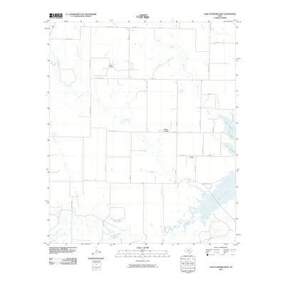
2010 Map of Lake Stamford West
USGS Topo · Published 2010About this map
Lake Stamford dominates the eastern horizon of this West Texas landscape, where the waters of Paint Creek flow through a grid of rural ranch roads and agricultural tracts. The terrain is defined by a dense network of seasonal drainages, including Mule Creek, Buffalo Creek, and Rice Springs Branch, which carve through the plains. The presence of the Haskell Oil Field in the northern portion of the quadrangle points to the region's long-standing reliance on petroleum extraction. Near the center of the survey, the small settlement of Paint Creek serves as a local hub, while the Howard Cemetery on Cemetary Rd provides a specific point of interest for those researching local family histories and early landholdings. This survey captures a rural Texas economy transitioning into the twenty-first century, balancing traditional ranching with established energy production near the lake's western shore.
Find a feature on this map
38 named features on this map. Tap any name to fly to it.
Don’t see what you’re looking for? This feature index may not catch every label — zoom into the map to look around manually.
Map Details
Editions of this 2010 Lake Stamford West Map
This is the sole edition of this map. No revisions or reprints were ever made.
Other maps of this area

1891 · Anson
USGS Topo · 1:125,000

1893 · Anson
USGS Topo · 1:125,000

1954 · Abilene
USGS Topo · 1:250,000

1954 · Wichita Falls
USGS Topo · 1:250,000

1958 · Wichita Falls
USGS Topo · 1:250,000

1958 · Abilene
USGS Topo · 1:250,000

1965 · Lueders NW
USGS Topo · 1:24,000

1965 · Lueders NE
USGS Topo · 1:24,000
1965 · Stamford
USGS Topo · 1:24,000

1966 · Haskell
USGS Topo · 1:24,000