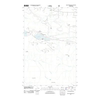
2011 Map of Lake Sutherland
USGS Topo · Published 2011About this map
Lake Sutherland and the eastern edge of Lake Crescent dominate this Olympic Peninsula landscape, showing the concentration of lakeside activity early in the twenty-first century. Small communities like Maple Grove and Snug Harbor line the shores of Sutherland, connected by S Shore Rd, while East Beach serves as a primary access point to the larger Crescent Lake. This survey illustrates the sharp contrast between the developed waterfronts and the surrounding high country of the Olympic National Forest. Steep terrain rises immediately from the water to heights like Mount Storm King and Lizard Head Peak. To the south, the map traces the drainage of Barnes Creek and Happy Lake Creek, leading to the isolated Happy Lake high on Happy Lake Ridge. The northern section reveals a more fractured landscape of rural roads around Ramapo, including Liljedahl Rd and Vert Rd.
Find a feature on this map
53 named features on this map. Tap any name to fly to it.
Don’t see what you’re looking for? This feature index may not catch every label — zoom into the map to look around manually.
Map Details
Editions of this 2011 Lake Sutherland Map
This is the sole edition of this map. No revisions or reprints were ever made.
Other maps of this area

1918 · Lake Crescent
USGS Topo · 1:62,500

1919 · Port Crescent
USGS Topo · 1:62,500

1922 · Lake Crescent
USGS Topo · 1:62,500

1935 · Mount Olympus
USGS Topo · 1:62,500

1939 · Mount Tom
USGS Topo · 1:62,500

1942 · Mount Olympus
USGS Topo · 1:62,500

1950 · Elwha
USGS Topo · 1:24,000

1950 · Hurricane Hill
USGS Topo · 1:24,000

1950 · Lake Sutherland
USGS Topo · 1:24,000
1950 · Angeles Point
USGS Topo · 1:24,000