1942 Map of Lake Tapps
USGS Topo · Published 1980About this map
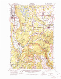
The Lake Tapps reservoir and the converging Carbon River and Puyallup River define this 1942 landscape of timber, coal, and agriculture. The map documents a pivotal era for Pierce County and King County, where industrial logging and mining operations intersect with established farming communities. Researchers can trace the extensive Logging RR network and various Coal Mines near Wilkeson and Carbonado, providing a clear look at the region’s resource-based economy before later residential expansion.
Find a feature on this map
85 named features on this map. Tap any name to fly to it.
Don’t see what you’re looking for? This feature index may not catch every label — zoom into the map to look around manually.
Map Details
Editions of this 1942 Lake Tapps Map
3 editions found

Other maps of this area

1897 · Tacoma
USGS Topo · 1:125,000

1900 · Tacoma
USGS Topo · 1:125,000

1913 · Cedar Lake
USGS Topo · 1:125,000

1924 · Mt Rainier
USGS Topo · 1:96,000

1928 · Mt Rainier
USGS Topo · 1:125,000

1937 · Eatonville
USGS Topo · 1:125,000

1941 · Tanwax Lake
USGS Topo · 1:62,500

1941 · Tacoma South
USGS Topo · 1:62,500

1942 · Lake Tapps
USGS Topo · 1:62,500

1944 · Lake Tapps
USGS Topo · 1:62,500