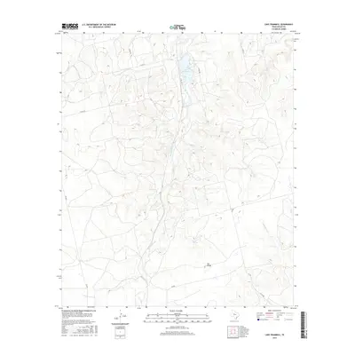
2016 Map of Lake Trammell
USGS Topo · Published 2016About this map
Lake Trammell serves as the central focal point for this section of Nolan County, where the high plains landscape is defined by the headwaters of numerous branching drainages. The local geography is marked by The Divide, a topographic rise that separates the complex networks of Sweetwater Cr and Spring Cr. This area represents a transition in the Texas landscape where the flat upland reaches are increasingly dissected by erosion, creating the distinct valleys of Cottonwood Cr and Seale Cr. Rural transportation is maintained by a grid of county roads, including Co RD 147 and FM 608, which connect isolated homesteads to the wider region. Notable natural landmarks like Rock Springs provide specific points of interest for those studying the hydrology and original settlement patterns of this semi-arid environment.
Find a feature on this map
18 named features on this map. Tap any name to fly to it.
Don’t see what you’re looking for? This feature index may not catch every label — zoom into the map to look around manually.
Map Details
Editions of this 2016 Lake Trammell Map
This is the sole edition of this map. No revisions or reprints were ever made.
Other maps of this area

1893 · Sweetwater
USGS Topo · 1:125,000

1954 · Big Spring
USGS Topo · 1:250,000

1958 · Big Spring
USGS Topo · 1:250,000

1969 · Bench Mountain
USGS Topo · 1:24,000

1969 · Blackwell NE
USGS Topo · 1:24,000

1969 · Maryneal
USGS Topo · 1:24,000
1969 · Dew Drop Creek
USGS Topo · 1:24,000

1969 · Roscoe
USGS Topo · 1:24,000

1969 · Sweetwater
USGS Topo · 1:24,000

1969 · Holder Creek
USGS Topo · 1:24,000