
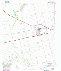
1969 Map of Roscoe
USGS Topo · Published 1972About this map
Roscoe serves as the focal point of this West Texas landscape during the late 1960s, defined by its position at the intersection of critical transit and energy corridors. The town is anchored by its community infrastructure, including the High Sch, an Athletic Field, and Roscoe Cem Cemetery, reflecting a settled agricultural and industrial hub. The presence of the Texas and Pacific and the Roscoe Snyder and Pacific railroads underscores the importance of rail transport for both regional goods and the local economy. Beyond the town grid, the landscape is marked by the Oil and Gas Field and numerous Gravel Pits, while a network of pipelines crisscrosses the terrain. Rural connectivity is maintained through family-named routes like Jarratt Norris Road and Duncan Hastings Road, which link the town to the surrounding plains and the winding course of Cottonwood Creek.
Find a feature on this map
22 named features on this map. Tap any name to fly to it.
Don’t see what you’re looking for? This feature index may not catch every label — zoom into the map to look around manually.
Map Details
Editions of this 1969 Roscoe Map
2 editions found
Other maps of this area

1893 · Roby
USGS Topo · 1:125,000

1893 · Sweetwater
USGS Topo · 1:125,000

1954 · Big Spring
USGS Topo · 1:250,000

1958 · Big Spring
USGS Topo · 1:250,000

1969 · Baumann School
USGS Topo · 1:24,000

1969 · Busby
USGS Topo · 1:24,000

1969 · Bench Mountain
USGS Topo · 1:24,000

1969 · Loraine
USGS Topo · 1:24,000

1969 · Bernecker
USGS Topo · 1:24,000

1969 · Sweetwater
USGS Topo · 1:24,000