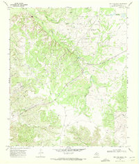
1969 Map of Dew Drop Creek
USGS Topo · Published 1972About this map
The Nena Lucia Oil Field dominates this 1960s landscape in Nolan County, characterized by a complex network of pipelines, pumping stations, and scattered oil wells. This industrial footprint is woven into a terrain defined by the drainage systems of Big Silver Creek and Dew Drop Creek, which carve through the West Texas ranch land. The southern portion of the map reveals the small settlement of Adair and the rail operations at Maddox, serving as quiet anchors for the local economy during this era.
Find a feature on this map
23 named features on this map. Tap any name to fly to it.
Don’t see what you’re looking for? This feature index may not catch every label — zoom into the map to look around manually.
Map Details
Editions of this 1969 Dew Drop Creek Map
2 editions found
Other maps of this area

1893 · Sweetwater
USGS Topo · 1:125,000

1954 · Big Spring
USGS Topo · 1:250,000

1958 · Big Spring
USGS Topo · 1:250,000

1959 · Dam Draw
USGS Topo · 1:24,000

1959 · Silver
USGS Topo · 1:24,000

1962 · Sanco
USGS Topo · 1:24,000

1969 · Baumann School
USGS Topo · 1:24,000

1969 · Bench Mountain
USGS Topo · 1:24,000

1969 · Maryneal
USGS Topo · 1:24,000
1969 · Blackwell SW
USGS Topo · 1:24,000