
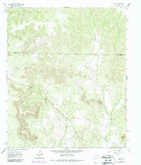
1962 Map of Sanco
USGS Topo · Published 1964About this map
Sanco serves as the primary landmark in this 1962 topographical study of West Texas, situated in a landscape where industrial expansion meets rugged terrain. The survey captures a moment of active resource extraction, dominated by the I A B Oil Field and numerous Oil Wells and Gas Wells scattered throughout the valleys. Natural features define the horizon, including prominent elevations such as Horse Mountain, Meadow Mountain, and Durham Peak. Drainage patterns are dictated by the paths of Yellow Wolf Creek and Adair Creek, which cut through the hills. A notable boundary line for Nolan Co Coke Co runs across the northern section, marking the political division of the ranch and oil country. The presence of a Gravel Pit and a major Pipeline further illustrates the mid-century infrastructure supporting the local economy.
Find a feature on this map
15 named features on this map. Tap any name to fly to it.
Don’t see what you’re looking for? This feature index may not catch every label — zoom into the map to look around manually.
Map Details
Editions of this 1962 Sanco Map
2 editions found
Other maps of this area

1891 · Hayrick
USGS Topo · 1:125,000

1893 · Sweetwater
USGS Topo · 1:125,000

1894 · Hayrick
USGS Topo · 1:125,000

1954 · Big Spring
USGS Topo · 1:250,000

1954 · San Angelo
USGS Topo · 1:250,000

1958 · San Angelo
USGS Topo · 1:250,000

1958 · Big Spring
USGS Topo · 1:250,000

1959 · Dam Draw
USGS Topo · 1:24,000

1959 · Silver
USGS Topo · 1:24,000

1962 · Edith
USGS Topo · 1:24,000