
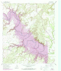
1962 Map of Edith
USGS Topo · Published 1964About this map
The Colorado River carves a winding path through this portion of Coke County, defining a landscape marked by deep creek drainages and early energy exploration. Near the settlement of Edith, the terrain is punctuated by numerous quarries, oil wells, and a gas well, reflecting the mid-century industrial activity in the region. The map provides significant genealogical value through the presence of the Sanco Cem in the northeast and family-named landmarks like Elm Bend. Distinctive hydrologic features such as Dripping Springs and the convergence of Yellow Wolf Creek with the river highlight the complex drainage network of Messbox Creek and Wildcat Creek that feeds the main river valley. This 1962 field-checked survey also captures fine details like selected fence lines and a sandpit, offering a precise view of rural land use before modern developments.
Find a feature on this map
18 named features on this map. Tap any name to fly to it.
Don’t see what you’re looking for? This feature index may not catch every label — zoom into the map to look around manually.
Map Details
Editions of this 1962 Edith Map
2 editions found
Other maps of this area

1891 · Hayrick
USGS Topo · 1:125,000

1893 · Sweetwater
USGS Topo · 1:125,000

1894 · Hayrick
USGS Topo · 1:125,000

1954 · Big Spring
USGS Topo · 1:250,000

1954 · San Angelo
USGS Topo · 1:250,000

1958 · San Angelo
USGS Topo · 1:250,000

1958 · Big Spring
USGS Topo · 1:250,000

1959 · Silver
USGS Topo · 1:24,000

1962 · Sanco
USGS Topo · 1:24,000
1962 · Cement Mountain
USGS Topo · 1:24,000