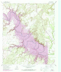
1962 Map of Edith
USGS Topo · Published 1988About this map
The Colorado River Lake E V Spence dominates this portion of Coke County, where the landscape underwent a massive transformation between the early 1960s and late 1980s. While the initial topography was documented in 1961, the 1987 revisions utilize purple hatching to identify areas slated for submergence following the construction of the Robert Lee Dam. This shift from a riverine valley to a massive reservoir altered the local geography around Edith, drowning numerous tributaries such as Yellow Wolf Creek and Rough Creek.
Find a feature on this map
24 named features on this map. Tap any name to fly to it.
Don’t see what you’re looking for? This feature index may not catch every label — zoom into the map to look around manually.
Map Details
Editions of this 1962 Edith Map
2 editions found
Other maps of this area

1891 · Hayrick
USGS Topo · 1:125,000

1893 · Sweetwater
USGS Topo · 1:125,000

1894 · Hayrick
USGS Topo · 1:125,000

1954 · Big Spring
USGS Topo · 1:250,000

1954 · San Angelo
USGS Topo · 1:250,000

1958 · San Angelo
USGS Topo · 1:250,000

1958 · Big Spring
USGS Topo · 1:250,000

1959 · Silver
USGS Topo · 1:24,000

1962 · Edith
USGS Topo · 1:24,000

1962 · Sanco
USGS Topo · 1:24,000