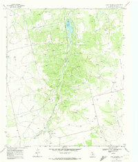
1969 Map of Lake Trammell
USGS Topo · Published 1973About this map
Lake Trammell Oil Field dominates this 1969 survey of the West Texas landscape, showing a dense network of extraction infrastructure including numerous Oil Wells, Drill Holes, and Pipelines. The central feature, Lake Trammell, is supported by a series of Aqueducts and a Pumping Sta, highlighting the region's managed water resources. The Atchison Topeka and Santa Fe railroad corridor cuts north-south through the terrain, paralleling Sweetwater Creek. Along the eastern edge, Old Railroad Grade and The Divide mark historical transportation routes and geographical boundaries. This map captures the industrial character of Nolan County during a peak era of petroleum development, from the Sixtynine Ranch in the south to the remote Landing Strip and varied water sources like Rock Springs and Finn Creek.
Find a feature on this map
25 named features on this map. Tap any name to fly to it.
Don’t see what you’re looking for? This feature index may not catch every label — zoom into the map to look around manually.
Map Details
Editions of this 1969 Lake Trammell Map
This is the sole edition of this map. No revisions or reprints were ever made.
Other maps of this area

1893 · Sweetwater
USGS Topo · 1:125,000

1954 · Big Spring
USGS Topo · 1:250,000

1958 · Big Spring
USGS Topo · 1:250,000

1969 · Bench Mountain
USGS Topo · 1:24,000

1969 · Blackwell NE
USGS Topo · 1:24,000

1969 · Maryneal
USGS Topo · 1:24,000
1969 · Dew Drop Creek
USGS Topo · 1:24,000

1969 · Roscoe
USGS Topo · 1:24,000

1969 · Sweetwater
USGS Topo · 1:24,000

1969 · Holder Creek
USGS Topo · 1:24,000