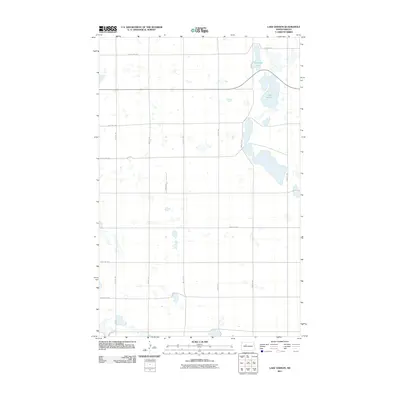
2011 Map of Lake Vernon
USGS Topo · Published 2011About this map
Lake Vernon and Tangedahl Lake dominate the northeastern landscape of this Ward County territory, where the terrain is defined by the unique prairie pothole hydrology of the North Dakota plains. The survey illustrates a meticulous section-line road network, including arterial routes like 303rd Ave SW and 142nd St SW, which trace the rigid grid of rural settlement. This early 21st-century documentation by the U.S. Geological Survey reveals a landscape of scattered seasonal wetlands and small basins, characteristic of the region's glacial legacy. While the area lacks dense municipal centers, the infrastructure shown through roads like 212th St SW and 345th Ave SW provides essential context for modern property boundaries and agricultural land use in this open, water-dotted prairie.
Find a feature on this map
17 named features on this map. Tap any name to fly to it.
Don’t see what you’re looking for? This feature index may not catch every label — zoom into the map to look around manually.
Map Details
Editions of this 2011 Lake Vernon Map
This is the sole edition of this map. No revisions or reprints were ever made.
Other maps of this area

1928 · Minot
USGS Topo · 1:62,500

1954 · Minot
USGS Topo · 1:250,000

1954 · McClusky
USGS Topo · 1:250,000

1956 · Blue Hill
USGS Topo · 1:24,000

1956 · Douglas West
USGS Topo · 1:24,000

1958 · McClusky
USGS Topo · 1:250,000

1958 · Minot
USGS Topo · 1:250,000

1980 · Minot
USGS Topo · 1:100,000

1980 · Lake Vernon
USGS Topo · 1:24,000
1980 · Douglas East
USGS Topo · 1:24,000