
2014 Map of Lake Vernon
USGS Topo · Published 2014About this map
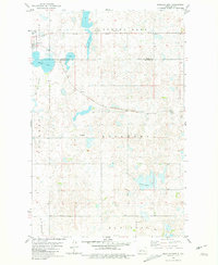
Lake Vernon and the smaller Tangedahl Lake anchor the northeastern corner of this Ward County landscape, where the prairie is defined by a dense concentration of small potholes and depressions. This 2014 survey captures the section-line road grid that characterizes the region, with ND-23 serving as the primary east-west corridor cutting through the northern portion of the quadrangle. The terrain is marked by subtle elevation changes and numerous seasonal water bodies, typical of the glacial drift plains of North Dakota. Land use is predominantly agricultural, evidenced by the precise network of rural routes including 233rd Ave SW and 345th Ave SW. While the map lacks named settlements, the spatial arrangement of the section roads and the names of the local water bodies provide essential geographic context for family historians tracing rural residents in the western part of the state.
Find a feature on this map
19 named features on this map. Tap any name to fly to it.
Don’t see what you’re looking for? This feature index may not catch every label — zoom into the map to look around manually.
Map Details
Editions of this 2014 Lake Vernon Map
This is the sole edition of this map. No revisions or reprints were ever made.
Other maps of this area

1928 · Minot
USGS Topo · 1:62,500

1954 · Minot
USGS Topo · 1:250,000

1954 · McClusky
USGS Topo · 1:250,000

1956 · Blue Hill
USGS Topo · 1:24,000

1956 · Douglas West
USGS Topo · 1:24,000

1958 · McClusky
USGS Topo · 1:250,000

1958 · Minot
USGS Topo · 1:250,000

1980 · Minot
USGS Topo · 1:100,000

1980 · Lake Vernon
USGS Topo · 1:24,000
1980 · Douglas East
USGS Topo · 1:24,000