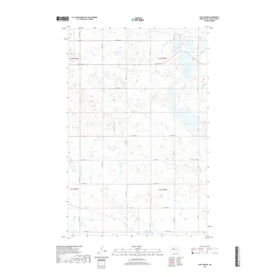
2017 Map of Lake Vernon
USGS Topo · Published 2017About this map
Lake Vernon and Tangedahl Lake dominate the northeastern portion of this Ward County landscape, where the prairie is defined by a dense network of glacial potholes and wetlands. The topography is marked by these numerous small basins, which create a complex drainage pattern across the township lines of t152n r86w, t152n r85w, and the surrounding sections. A rigid grid of section-line roads, including 247th Ave SW and 261st Ave SW, provides the primary access through this agricultural region. The intersection of Co Hwy 22 and Co Hwy 13 serves as a local transit corridor, while the scattered wetlands indicate a terrain that remains closely tied to the natural water cycle of the Northern Plains. This survey provides a clear view of how modern rural infrastructure follows the Public Land Survey System to manage this water-rich environment.
Find a feature on this map
15 named features on this map. Tap any name to fly to it.
Don’t see what you’re looking for? This feature index may not catch every label — zoom into the map to look around manually.
Map Details
Editions of this 2017 Lake Vernon Map
This is the sole edition of this map. No revisions or reprints were ever made.
Other maps of this area

1928 · Minot
USGS Topo · 1:62,500

1954 · Minot
USGS Topo · 1:250,000

1954 · McClusky
USGS Topo · 1:250,000

1956 · Blue Hill
USGS Topo · 1:24,000

1956 · Douglas West
USGS Topo · 1:24,000

1958 · McClusky
USGS Topo · 1:250,000

1958 · Minot
USGS Topo · 1:250,000

1980 · Minot
USGS Topo · 1:100,000

1980 · Lake Vernon
USGS Topo · 1:24,000
1980 · Douglas East
USGS Topo · 1:24,000