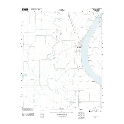
2011 Map of Lake Village
USGS Topo · Published 2011About this map
Lake Chicot dominates the eastern landscape of Chicot County, its distinctive oxbow curve shaping the development of Lake Village and surrounding settlements. This 2011 survey captures the area's delta character, where a complex network of waterways including Bayou Macon, Little Lake Bayou, and Paps Slough weave through agricultural land defined by long-established section lines. The map is particularly dense with genealogical sites, recording numerous burial grounds like Mount Zion Cemetery and Liberty Cemetery. Small communities such as Chanticleer, Fairview, and Jennie are linked by a grid of rural roads, including 16th Section Rd and Roy Broach Rd. Engineered water controls like the Lake Chicot Dam North and Whiskey Chute Dam highlight the ongoing management of the region's prominent aquatic features.
Find a feature on this map
73 named features on this map. Tap any name to fly to it.
Don’t see what you’re looking for? This feature index may not catch every label — zoom into the map to look around manually.
Map Details
Editions of this 2011 Lake Village Map
This is the sole edition of this map. No revisions or reprints were ever made.
Other maps of this area

1936 · Eudora
USGS Topo · 1:62,500

1936 · Lake Village
USGS Topo · 1:62,500

1939 · Readland
USGS Topo · 1:62,500

1939 · Refuge
USGS Topo · 1:62,500

1953 · Greenwood
USGS Topo · 1:250,000

1955 · Lake Village
USGS Topo · 1:62,500

1956 · Greenwood
USGS Topo · 1:250,000

1957 · Eudora
USGS Topo · 1:62,500
1970 · Luna
USGS Topo · 1:24,000
1970 · Red Leaf
USGS Topo · 1:24,000