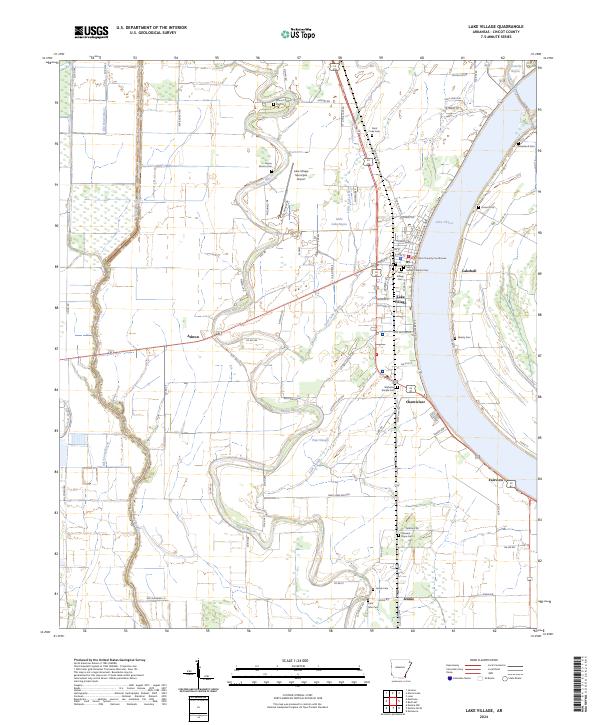
2024 Map of Lake Village
USGS Topo · Published 2024About this map
Lake Chicot dominates the eastern edge of this landscape, its distinctive oxbow curve defining the character of the river delta region. In the heart of Lake Village, the Chicot County Courthouse serves as a central landmark for a community shaped by its proximity to both the water and the fertile agricultural land surrounding it. The map traces the intricate water network of the area, where Bayou Macon and Little Lake Bayou snake through the flatlands, interspersed with small settlements like Chanticleer and Fairview. Genealogists will find a wealth of local history preserved in the numerous burial grounds documented here, including Saint Isidore Catholic Cem, the Lake Village Cem, and the more remote Woodson Temple Cem and Pleasant Hope Cem. The transition from the town center to rural outposts like Jennie and Ashton illustrates the enduring layout of Chicot County's road and water systems.
Find a feature on this map
106 named features on this map. Tap any name to fly to it.
Don’t see what you’re looking for? This feature index may not catch every label — zoom into the map to look around manually.
Map Details
Editions of this 2024 Lake Village Map
This is the sole edition of this map. No revisions or reprints were ever made.
Historical Maps of Myrtle Grove Through Time
4 maps found