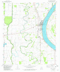
1981 Map of Lake Village
USGS Topo · Published 1982About this map
Lake Chicot dominates the eastern half of this Delta landscape, its distinct oxbow shape defining the development of Lake Village. The town sits along the lake's inner curve, where the Missouri Pacific railroad line runs parallel to the shore, passing by Lakeside High Sch and Chicot Memorial Hospital. Outside the main settlement, the land is etched by a complex drainage network including the winding Macon Bayou and the Boeuf River, which flow through a region heavily utilized for agriculture and aquaculture, as evidenced by the Fish Farm near the western edge. Small rural communities like Jennie and Fairview anchor the south, while several country churches and cemeteries, such as Bayou Macon Ch Cem and Woodson Temple, provide important markers for local family history and genealogy.
Find a feature on this map
40 named features on this map. Tap any name to fly to it.
Don’t see what you’re looking for? This feature index may not catch every label — zoom into the map to look around manually.
Map Details
Editions of this 1981 Lake Village Map
This is the sole edition of this map. No revisions or reprints were ever made.
Other maps of this area

1936 · Eudora
USGS Topo · 1:62,500

1936 · Lake Village
USGS Topo · 1:62,500

1939 · Readland
USGS Topo · 1:62,500

1939 · Refuge
USGS Topo · 1:62,500

1953 · Greenwood
USGS Topo · 1:250,000

1955 · Lake Village
USGS Topo · 1:62,500

1956 · Greenwood
USGS Topo · 1:250,000

1957 · Eudora
USGS Topo · 1:62,500
1970 · Luna
USGS Topo · 1:24,000
1970 · Red Leaf
USGS Topo · 1:24,000