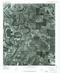
1975 Map of Lake Village NW
USGS Topo · Published 1976About this map
The low-lying alluvial plains of Chicot County are defined by the winding course of Bartholomew Bayou, which meanders across the landscape in a series of tight oxbows and ancient river scars. This 1975 orthophotoquad reveals the intricate relationship between water and agriculture in the Delta region, showing how field patterns follow the natural curvature of the bayous. The settlement of Jerome sits along the western edge of this drainage system, serving as a focal point in a territory dominated by large-scale farming and drainage networks like Big Bayou. Unlike traditional topographic maps, this aerial imagery captures the precise texture of the forest stands and the muddy banks of the waterways as they appeared during the mid-1970s.
Find a feature on this map
3 named features on this map. Tap any name to fly to it.
Don’t see what you’re looking for? This feature index may not catch every label — zoom into the map to look around manually.
Map Details
Editions of this 1975 Lake Village NW Map
This is the sole edition of this map. No revisions or reprints were ever made.
Other maps of this area

1935 · Mist
USGS Topo · 1:62,500

1935 · Cominto
USGS Topo · 1:62,500

1936 · McGehee
USGS Topo · 1:62,500

1936 · Lake Village
USGS Topo · 1:62,500

1937 · McGehee
USGS Topo · 1:62,500

1953 · Greenwood
USGS Topo · 1:250,000

1955 · Lake Village
USGS Topo · 1:62,500

1955 · McGehee
USGS Topo · 1:62,500

1956 · Greenwood
USGS Topo · 1:250,000

1960 · Snyder
USGS Topo · 1:24,000