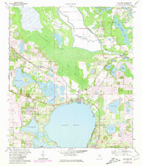
1970 Map of Lake Weir
USGS Topo · Published 1980About this map
The Lake Weir basin dominates this central Florida landscape, serving as a focal point for lakeside communities like Oklawaha and Eastlake Weir during the early 1970s. The northern reaches of the sheet are defined by the transition from the Marshall Swamp into the dense timber of the Ocala National Forest. Along the winding Oklawaha River, infrastructure such as the Moss Bluff Lock and Dam and the Gaging Sta reflect the mid-century management of the region's complex water systems.
Find a feature on this map
42 named features on this map. Tap any name to fly to it.
Don’t see what you’re looking for? This feature index may not catch every label — zoom into the map to look around manually.
Map Details
Editions of this 1970 Lake Weir Map
4 editions found
Other maps of this area

1893 · Panasoffkee
USGS Topo · 1:62,500

1895 · Panasoffkee
USGS Topo · 1:62,500

1895 · Ocala
USGS Topo · 1:62,500

1954 · Gainesville
USGS Topo · 1:250,000

1954 · Daytona Beach
USGS Topo · 1:250,000

1955 · Plant City
USGS Topo · 1:250,000

1955 · Orlando
USGS Topo · 1:250,000

1957 · Orlando
USGS Topo · 1:250,000

1958 · Orlando
USGS Topo · 1:250,000

1958 · Daytona Beach
USGS Topo · 1:250,000