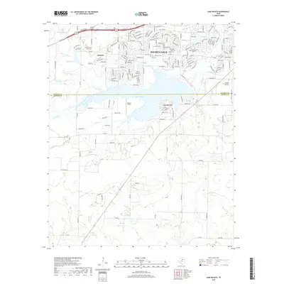
2019 Map of Lake Wichita
USGS Topo · Published 2019About this map
Lake Wichita serves as the central focal point of this North Texas landscape, straddling the border between Wichita County and Archer County. The map documents the southern expansion of Wichita Falls, where suburban neighborhoods like Allendale meet the irrigation infrastructure of the Call Field Canal and C E Lateral. To the south, Lakeside City sits prominently along the eastern shore, while the surrounding plains are marked by a series of family and community landmarks, including Bowman Cem and the Danaher Airport. The complex network of water management is visible through features like the C H Lateral and Secondary Reservoir, reflecting the region's managed hydraulic environment. Several burial grounds, such as Rosemont Cem and Crestview Memorial Park Cem, provide essential anchor points for genealogical research in this developing corridor.
Find a feature on this map
183 named features on this map. Tap any name to fly to it.
Don’t see what you’re looking for? This feature index may not catch every label — zoom into the map to look around manually.
Map Details
Editions of this 2019 Lake Wichita Map
This is the sole edition of this map. No revisions or reprints were ever made.
Other maps of this area

1916 · Iowa Park
USGS Topo · 1:24,000

1918 · Iowa Park
USGS Topo · 1:31,680

1931 · Archer City
USGS Topo · 1:62,500

1954 · Wichita Falls
USGS Topo · 1:250,000

1956 · Sloop Creek
USGS Topo · 1:24,000

1956 · Lake Wichita
USGS Topo · 1:24,000

1957 · Wichita Falls West
USGS Topo · 1:24,000

1957 · Wichita Falls East
USGS Topo · 1:62,500

1957 · Wichita Falls East
USGS Topo · 1:24,000

1957 · Wichita Falls West
USGS Topo · 1:62,500