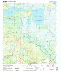
1999 Map of Lake Woodruff
USGS Topo · Published 2001About this map
The St Johns River carves a winding path through this wetland-dominated landscape, connecting the expansive waters of Lake Dexter and Lake Woodruff. The area is defined by its complex hydrology of marshy islands and tributary creeks like Alexander Spring Creek and Tick Island Creek. Settlement is sparse, concentrated at riverine access points such as Shell Landing and Hickory Landing. On the southern edge, the community of Fullerville and the residential development at Lake Kathryn Heights represent more established upland habitation near the Lake Kathryn shoreline.
Find a feature on this map
60 named features on this map. Tap any name to fly to it.
Don’t see what you’re looking for? This feature index may not catch every label — zoom into the map to look around manually.
Map Details
Editions of this 1999 Lake Woodruff Map
This is the sole edition of this map. No revisions or reprints were ever made.
Other maps of this area

1954 · Daytona Beach
USGS Topo · 1:250,000

1955 · Orlando
USGS Topo · 1:250,000

1957 · Orlando
USGS Topo · 1:250,000

1958 · Orlando
USGS Topo · 1:250,000

1958 · Daytona Beach
USGS Topo · 1:250,000

1962 · Orlando
USGS Topo · 1:250,000

1962 · Pine Lakes
USGS Topo · 1:24,000

1962 · Lake Woodruff
USGS Topo · 1:24,000

1964 · Daytona Beach
USGS Topo · 1:250,000
1964 · De Land
USGS Topo · 1:24,000