
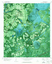
2011 Map of Lakeland
USGS Topo · Published 2011About this map
Lakeland serves as the central hub of this Georgia landscape, situated at the confluence of several significant water bodies including Lake Irma and Mill Creek. The town's civic core is anchored by the Courthouse, while the surrounding terrain is defined by the expansive Banks Lake to the west, featuring the distinctive Pine Islands and Lightsey Hammock. This 2011 survey documents a region where water management and local geography are deeply intertwined, evidenced by the series of structures like the Banks Lake Dam and Lake Irma Dam.
Find a feature on this map
54 named features on this map. Tap any name to fly to it.
Don’t see what you’re looking for? This feature index may not catch every label — zoom into the map to look around manually.
Map Details
Editions of this 2011 Lakeland Map
This is the sole edition of this map. No revisions or reprints were ever made.
Other maps of this area

1953 · Waycross
USGS Topo · 1:250,000

1954 · Valdosta
USGS Topo · 1:250,000

1958 · Valdosta
USGS Topo · 1:250,000

1958 · Waycross
USGS Topo · 1:250,000

1959 · Valdosta
USGS Topo · 1:250,000

1968 · Naylor
USGS Topo · 1:24,000

1968 · Lakeland
USGS Topo · 1:24,000

1971 · Stockton
USGS Topo · 1:24,000
1971 · Bemiss
USGS Topo · 1:24,000

1972 · Sirmans
USGS Topo · 1:24,000