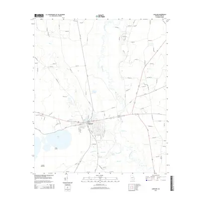
2014 Map of Lakeland
USGS Topo · Published 2014About this map
Lakeland serves as the central hub of this Lanier County landscape, positioned at a vital junction of state routes and local thoroughfares. To the west, the expansive Banks Lake and its distinctive Pine Islands dominate the terrain, while the meandering Alapaha River carves a path through the eastern half of the map. The area's agricultural and industrial heritage is quietly noted through features like Darsey Mill Br and several large ponds, including Pattens Pond and Darsey Pond. For those tracing local history, the map includes the isolated Lovejoy Cem to the southeast and hints at former community centers along Crisp School Rd. The natural environment is defined by low-lying wetlands and hammocks, such as Lightsey Hammock, contrasting with the orderly grid of the town site centered around Lake Irma and its surrounding street network.
Find a feature on this map
96 named features on this map. Tap any name to fly to it.
Don’t see what you’re looking for? This feature index may not catch every label — zoom into the map to look around manually.
Map Details
Editions of this 2014 Lakeland Map
This is the sole edition of this map. No revisions or reprints were ever made.
Other maps of this area

1953 · Waycross
USGS Topo · 1:250,000

1954 · Valdosta
USGS Topo · 1:250,000

1958 · Valdosta
USGS Topo · 1:250,000

1958 · Waycross
USGS Topo · 1:250,000

1959 · Valdosta
USGS Topo · 1:250,000

1968 · Naylor
USGS Topo · 1:24,000

1968 · Lakeland
USGS Topo · 1:24,000

1971 · Stockton
USGS Topo · 1:24,000
1971 · Bemiss
USGS Topo · 1:24,000

1972 · Sirmans
USGS Topo · 1:24,000