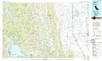
1994 Map of Lakeport
USGS Topo · Published 1994About this map
The western shores of Clear Lake anchor this 1994 map, showing the established communities of Lakeport and Kelseyville alongside the expansive waters. The landscape transitions sharply from the deep blue of the lake and the agricultural patterns of the Sacramento River valley to the east, into the high peaks of the Mendocino National Forest. Significant mercury and sulfur mining history is represented here at sites like the Sulphur Bank Mine and Abbott Mine, marking the region's geological and industrial heritage.
Find a feature on this map
93 named features on this map. Tap any name to fly to it.
Don’t see what you’re looking for? This feature index may not catch every label — zoom into the map to look around manually.
Map Details
Editions of this 1994 Lakeport Map
This is the sole edition of this map. No revisions or reprints were ever made.
Other maps of this area

1888 · Marysville
USGS Topo · 1:125,000

1891 · Chico
USGS Topo · 1:125,000

1891 · Marysville
USGS Topo · 1:125,000

1893 · Chico
USGS Topo · 1:125,000

1894 · Marysville
USGS Topo · 1:125,000

1895 · Marysville
USGS Topo · 1:125,000

1895 · Chico
USGS Topo · 1:125,000

1904 · Logan Creek
USGS Topo · 1:24,000

1904 · Sites
USGS Topo · 1:24,000

1905 · Harrington
USGS Topo · 1:24,000