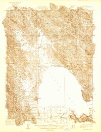
1983 Map of Lakeport
USGS Topo · Published 1983About this map
Lakeport and the surrounding agricultural valleys of Clear Lake are shown here following surveys conducted by J.P. Harrison in the early 1930s. The map illustrates a landscape of productive bottomlands and mountain ridges, where water flow from Scotts Creek and Middle Creek feeds into the massive lake basin. Rural education was central to these scattered communities, evidenced by the presence of the Blue Lake Sch, Glen Eden Sch, Liberty Sch, and Kelsey Creek Sch.
Find a feature on this map
57 named features on this map. Tap any name to fly to it.
Don’t see what you’re looking for? This feature index may not catch every label — zoom into the map to look around manually.
Map Details
Editions of this 1983 Lakeport Map
This is the sole edition of this map. No revisions or reprints were ever made.
Other maps of this area

1920 · Ukiah
USGS Topo · 1:62,500

1921 · Kelseyville
USGS Topo · 1:62,500

1922 · Hullville
USGS Topo · 1:62,500

1924 · Bartlett Springs
USGS Topo · 1:62,500

1938 · Lakeport
USGS Topo · 1:62,500

1938 · Hopland
USGS Topo · 1:62,500

1942 · Bartlett Springs
USGS Topo · 1:62,500

1943 · Pomo
USGS Topo · 1:62,500

1943 · Kelseyville
USGS Topo · 1:62,500

1943 · Hopland
USGS Topo · 1:62,500