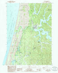
1985 Map of Lakeside
USGS Topo · Published 1985About this map
Tenmile Lake and its intricate arms dominate this coastal landscape on the border of Coos and Douglas counties. In the mid-1980s, the community of Lakeside serves as a central hub between the massive freshwater basins and the Pacific Ocean, which is buffered by the expansive sand dunes of the Oregon Dunes National Recreation Area. The map reveals a complex water system including Eel Lake, Clear Lake, and Saunders Lake, often bordered by state and federal parklands like William M Tugman State Park. Notable infrastructure is concentrated around the southern reach, including the Hauser Substation, a US Naval Reservation, and the North Bend Air Nat Guard Station. This area is characterized by a mix of recreation and technical sites, where Highway 101 provides the primary artery through timberlands and coastal wetlands like North Slough.
Find a feature on this map
52 named features on this map. Tap any name to fly to it.
Don’t see what you’re looking for? This feature index may not catch every label — zoom into the map to look around manually.
Map Details
Editions of this 1985 Lakeside Map
This is the sole edition of this map. No revisions or reprints were ever made.
Other maps of this area

1896 · Coos Bay
USGS Topo · 1:125,000

1898 · Coos Bay
USGS Topo · 1:125,000

1900 · Coos Bay
USGS Topo · 1:125,000

1923 · Reedsport
USGS Topo · 1:62,500

1942 · Reedsport
USGS Topo · 1:62,500

1942 · Empire
USGS Topo · 1:62,500

1942 · Coos Bay
USGS Topo · 1:62,500

1944 · Empire
USGS Topo · 1:62,500

1945 · Coos Bay
USGS Topo · 1:62,500

1954 · Coos Bay
USGS Topo · 1:250,000