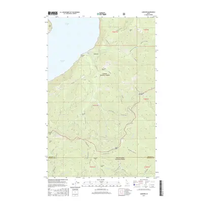
2017 Map of Lakeview
USGS Topo · Published 2017About this map
The settlement of Lakeview sits on the eastern shore of Lake Pend Oreille, serving as a gateway into the steep terrain of the Coeur d'Alene National Forest and Kaniksu National Forest. This interior region is defined by prominent elevations including Green Mountain and Prospect Peak, and is bisected by the Bonner and Kootenai County line. The landscape shows a clear history of resource extraction and transit through labels such as the Dixie Queen mine and a network of technical routes like Silver Leaf OHV and Cat Tail OHV. Waterways like North Gold Creek and Honey Creek drain the Coeur d'Alene Mountains, carving out landforms like Kick Bush Gulch. The road system, featuring the Lakeview Road and Bunco Road, illustrates the infrastructure required to navigate the mountain passes and connect the lakefront to the higher ridges.
Find a feature on this map
57 named features on this map. Tap any name to fly to it.
Don’t see what you’re looking for? This feature index may not catch every label — zoom into the map to look around manually.
Map Details
Editions of this 2017 Lakeview Map
This is the sole edition of this map. No revisions or reprints were ever made.
Other maps of this area

1901 · Sandpoint
USGS Topo · 1:125,000

1903 · Rathdrum
USGS Topo · 1:125,000

1909 · Cataldo
USGS Topo · 1:125,000

1911 · Cataldo
USGS Topo · 1:125,000

1911 · Priest Lake
USGS Topo · 1:250,000

1911 · Sandpoint
USGS Topo · 1:125,000

1913 · Priest Lake
USGS Topo · 1:250,000

1949 · Packsaddle Mtn
USGS Topo · 1:62,500

1951 · Packsaddle Mtn
USGS Topo · 1:62,500

1955 · Spokane
USGS Topo · 1:250,000