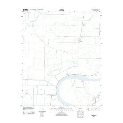
2011 Map of Lakeview
USGS Topo · Published 2011About this map
Old Town Lake anchors this portion of the Arkansas Delta, defining the geography around the community of Lakeview. The landscape is etched with the precise grid of Phillips County roads, serving a series of small agricultural settlements including Oneida, Wabash, and Trenton. This 2011 survey captures the area's transition into the modern era, showing the established infrastructure of the Oneida Post Office and Wabash Post Office alongside local landmarks like Saint Johns Cemetery and Mount Pleasant Cemetery. The presence of several family and community burial grounds, such as Salem Cemetery and Mount Olive Cemetery, offers significant data for genealogists tracing regional history. The mapping of named streets like Martin Luther King Dr and Michigan Ave in Lakeview illustrates the formal residential development situated just north of the lake's crescent-shaped shoreline.
Find a feature on this map
52 named features on this map. Tap any name to fly to it.
Don’t see what you’re looking for? This feature index may not catch every label — zoom into the map to look around manually.
Map Details
Editions of this 2011 Lakeview Map
This is the sole edition of this map. No revisions or reprints were ever made.
Other maps of this area

1939 · Farrell
USGS Topo · 1:62,500

1939 · Modoc
USGS Topo · 1:62,500

1939 · Latour
USGS Topo · 1:62,500

1940 · Marvell
USGS Topo · 1:62,500

1948 · Helena
USGS Topo · 1:250,000

1948 · Modoc
USGS Topo · 1:62,500

1950 · Helena
USGS Topo · 1:250,000

1955 · Latour
USGS Topo · 1:62,500
1955 · Farrell
USGS Topo · 1:62,500

1955 · Helena
USGS Topo · 1:250,000