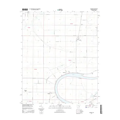
2014 Map of Lakeview
USGS Topo · Published 2014About this map
Lakeview and the surrounding Phillips County delta land are defined by the wide, sweeping curve of Old Town Lake, an oxbow remnant of the Mississippi River's ancient path. This 2014 survey documents a landscape dominated by agricultural fields and drainage networks, with small settlements like Oneida, Wabash, and Old Town situated along the primary transit corridors of Ar-44 and Ar-85. Local history is anchored by several rural burial grounds, including Salem Cem and Mt Pleasant Cem, which overlook the interior banks of the oxbow.
Find a feature on this map
56 named features on this map. Tap any name to fly to it.
Don’t see what you’re looking for? This feature index may not catch every label — zoom into the map to look around manually.
Map Details
Editions of this 2014 Lakeview Map
This is the sole edition of this map. No revisions or reprints were ever made.
Other maps of this area

1939 · Farrell
USGS Topo · 1:62,500

1939 · Modoc
USGS Topo · 1:62,500

1939 · Latour
USGS Topo · 1:62,500

1940 · Marvell
USGS Topo · 1:62,500

1948 · Helena
USGS Topo · 1:250,000

1948 · Modoc
USGS Topo · 1:62,500

1950 · Helena
USGS Topo · 1:250,000

1955 · Latour
USGS Topo · 1:62,500
1955 · Farrell
USGS Topo · 1:62,500

1955 · Helena
USGS Topo · 1:250,000