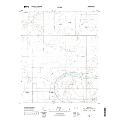
2020 Map of Lakeview
USGS Topo · Published 2020About this map
Lakeview sits at the northern edge of the sweeping curve of Old Town Lake, a prominent oxbow feature that defines the local landscape in Phillips County. This map documents a region characterized by its water-dependent geography and agricultural layout, where the community of Wabash serves as a junction point along Co Rd 432. The persistence of local history is evident in the numerous burial grounds scattered across the area, including Saint Johns Cem near Oneida and Mount Pleasant Cem situated closer to the lake shore. To the west, the winding path of McGehee Bayou and the flows of Lick Creek and Big Creek illustrate the complex drainage patterns of this Arkansas riverland. Small settlements like Trenton and Pilgrims Rest anchor the rural road network, providing a clear view of the area's residential and social distribution in the modern era.
Find a feature on this map
53 named features on this map. Tap any name to fly to it.
Don’t see what you’re looking for? This feature index may not catch every label — zoom into the map to look around manually.
Map Details
Editions of this 2020 Lakeview Map
This is the sole edition of this map. No revisions or reprints were ever made.
Other maps of this area

1939 · Farrell
USGS Topo · 1:62,500

1939 · Modoc
USGS Topo · 1:62,500

1939 · Latour
USGS Topo · 1:62,500

1940 · Marvell
USGS Topo · 1:62,500

1948 · Helena
USGS Topo · 1:250,000

1948 · Modoc
USGS Topo · 1:62,500

1950 · Helena
USGS Topo · 1:250,000

1955 · Latour
USGS Topo · 1:62,500
1955 · Farrell
USGS Topo · 1:62,500

1955 · Helena
USGS Topo · 1:250,000