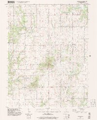
1998 Map of Lakewood
USGS Topo · Published 2003About this map
Lakewood serves as the central hub of this Shelby County landscape, where the flat agricultural plains of Central Illinois begin to roll toward more complex terrain. The topography is defined by significant elevations such as Williamsburg Hill and Coley Ridge, which disrupt the typical prairie grid. A network of waterways, including Mitchell Creek, Robinson Cr, and Polecat Creek, has historically shaped the settlement patterns and property lines of the surrounding townships.
Find a feature on this map
31 named features on this map. Tap any name to fly to it.
Don’t see what you’re looking for? This feature index may not catch every label — zoom into the map to look around manually.
Map Details
Editions of this 1998 Lakewood Map
This is the sole edition of this map. No revisions or reprints were ever made.
Other maps of this area

1941 · St. Elmo
USGS Topo · 1:62,500

1942 · Shelbyville
USGS Topo · 1:62,500

1944 · Ramsey
USGS Topo · 1:62,500

1945 · St. Elmo
USGS Topo · 1:62,500

1946 · Shelbyville
USGS Topo · 1:62,500

1946 · Ramsey
USGS Topo · 1:62,500

1947 · Pana
USGS Topo · 1:62,500

1949 · Pana
USGS Topo · 1:62,500

1958 · Decatur
USGS Topo · 1:250,000

1961 · Decatur
USGS Topo · 1:250,000