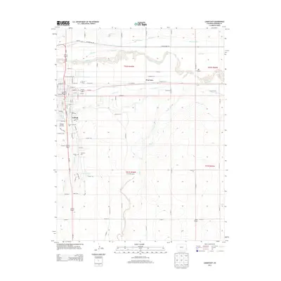
2013 Map of Lamar East
USGS Topo · Published 2013About this map
The Arkansas River corridor dominates this high-plains landscape, carrying water through an intricate network of irrigation systems including the Amity Canal, Hyde Canal, and Lamar Canal. The city of Lamar sits as the regional hub, with its grid expanding toward the Southeast Colorado Fairgrounds and the Lamar Community College campus. This 2013 survey provides a detailed view of the water management infrastructure essential to the area, tracing the Fort Bent Canal and the Lamar Reservoirs south of town. Genealogists will find three distinct burial grounds near the city center: Riverside Cem, Fairmount Cem, and Mt Olive Cem. The map also captures smaller satellite locales such as West Farm, Clucas, and Markham, alongside landmarks like the Lamar Waterworks and the wooded area of Big Timbers.
Find a feature on this map
83 named features on this map. Tap any name to fly to it.
Don’t see what you’re looking for? This feature index may not catch every label — zoom into the map to look around manually.
Map Details
Editions of this 2013 Lamar East Map
This is the sole edition of this map. No revisions or reprints were ever made.
Other maps of this area
1890 · Granada
USGS Topo · 1:125,000
1891 · Albany
USGS Topo · 1:125,000
1892 · Lamar
USGS Topo · 1:125,000
1892 · Granada
USGS Topo · 1:125,000
1892 · Two Butte
USGS Topo · 1:125,000
1893 · Two Butte
USGS Topo · 1:125,000
1893 · Albany
USGS Topo · 1:125,000
1894 · Granada
USGS Topo · 1:125,000
1952 · Lamar West
USGS Topo · 1:24,000
1952 · Carlton
USGS Topo · 1:24,000