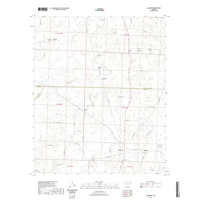
2020 Map of Lamartine
USGS Topo · Published 2020About this map
Sanders and Stockton anchor this part of Southwest Arkansas, where the landscape is defined by the winding creek bottoms and timberlands shared between Nevada, Lafayette, and Columbia counties. The region's rural character is evidenced by the high density of community burial grounds and houses of worship, such as New Hope Church Cem and Pleasant Hill Church Cem. Waterways like Bayou Dorcheat, Cypress Cr, and Beech Cr carve through the terrain, with Stockton Bottom representing the low-lying wetlands that influenced early settlement patterns. Small clusters of homes at Bethel, Delta, and Lamartine are connected by a network of local roads such as Columbia Road 31 and Nevada 17 Rd, showing a resilient rural framework that persisted into the twenty-first century. Genealogists will find the detailed locations of Waldrep Cem and Shiloh Cem particularly valuable for tracing local family histories.
Find a feature on this map
64 named features on this map. Tap any name to fly to it.
Don’t see what you’re looking for? This feature index may not catch every label — zoom into the map to look around manually.
Map Details
Editions of this 2020 Lamartine Map
This is the sole edition of this map. No revisions or reprints were ever made.
Other maps of this area

1901 · Gurdon
USGS Topo · 1:125,000

1953 · El Dorado
USGS Topo · 1:250,000

1957 · El Dorado
USGS Topo · 1:250,000

1958 · El Dorado
USGS Topo · 1:250,000

1960 · El Dorado
USGS Topo · 1:250,000

1968 · Buckner
USGS Topo · 1:24,000

1968 · Lamartine
USGS Topo · 1:24,000
1968 · Falcon
USGS Topo · 1:24,000

1968 · Waldo
USGS Topo · 1:24,000
1968 · Magnolia
USGS Topo · 1:24,000