
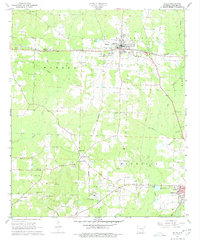
1968 Map of Waldo
USGS Topo · Published 1969About this map
The St Louis Southwestern railroad corridor anchors this late-1960s survey of Waldo, serving as the industrial and transit spine for Columbia County. The landscape is characterized by a high density of small rural landmarks, including numerous family-named cemeteries such as Barlow Cem and Rudd Cem, alongside traditional country congregations like Cedar Grove Ch and Antioch West Ch.
Find a feature on this map
50 named features on this map. Tap any name to fly to it.
Don’t see what you’re looking for? This feature index may not catch every label — zoom into the map to look around manually.
Map Details
Editions of this 1968 Waldo Map
2 editions found
Other maps of this area

1953 · El Dorado
USGS Topo · 1:250,000

1957 · El Dorado
USGS Topo · 1:250,000

1958 · El Dorado
USGS Topo · 1:250,000

1960 · El Dorado
USGS Topo · 1:250,000

1960 · Bussey
USGS Topo · 1:24,000

1960 · Macedonia
USGS Topo · 1:24,000

1966 · Calhoun
USGS Topo · 1:24,000

1968 · Buckner
USGS Topo · 1:24,000

1968 · Lamartine
USGS Topo · 1:24,000
1968 · Falcon
USGS Topo · 1:24,000